Baralacha La Pass Complete Guide (2026) – Height, Weather, Route & Travel Tips
 – Height, Weather, Route & Travel Tips 1")
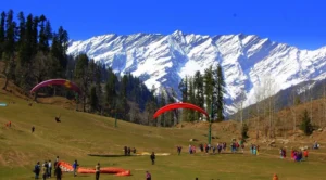
Baralacha La Pass Complete Guide – If you are planning a road trip on the Manali–Leh highway, crossing the Baralacha Pass is one of the most thrilling experiences.
Located at a staggering height of around 4,890 meters (16,040 feet), this high-altitude pass connects Lahaul in Himachal Pradesh to Ladakh and offers breathtaking views of snow-covered peaks, glaciers, and rugged landscapes.
This guide covers everything—baralacha temperature, weather, distance, height, itinerary, and travel tips.
Where is Baralacha La Pass?
Baralacha La is located on the Manali–Leh Highway (NH3) and acts as a crucial link between Himachal Pradesh and Ladakh.
– Region: Lahaul Valley
– Range: Zanskar Range
– Elevation: ~4,850–4,890 meters
It is also known as the “pass where multiple roads meet”, connecting routes from Lahaul, Ladakh, Spiti, and Zanskar.
Baralacha Height & Elevation
 – Height, Weather, Route & Travel Tips 2")
- Baralacha pass height: ~16,040 feet
- Baralacha la elevation: ~4,890 meters
- One of the highest motorable passes in India
This extreme altitude makes it both stunning and challenging
Baralacha La Temperature & Weather
General Weather
- Extremely cold throughout the year
- Strong winds + low oxygen
Baralacha Temperature (Approx)
| Season | Temperature |
|---|---|
| Summer (June–Sept) | 0°C to 10°C |
| Night (Summer) | -5°C to 0°C |
| Winter | -20°C to -30°C |
Even in summer, temperatures can drop below freezing
Baralacha La Weather Conditions
– Snow present even in June
– Sudden weather changes
– Risk of snowfall anytime
Always check baralacha pass temperature today before travel
Distance & Route Details
Manali to Baralacha Pass
- Distance: ~190 km
- Time: 7–8 hours
Keylong to Baralacha Pass
- Distance: ~73 km
Route
Manali → Atal Tunnel → Keylong → Jispa → Sarchu → Baralacha La
One of the most scenic drives in India
What Does Baralacha Pass Connect?
Baralacha La Pass connects:
– Lahaul (Himachal Pradesh)
– Ladakh
– Routes to Spiti Valley
It is also a water divide between Bhaga and Yunam rivers
Top Attractions Near Baralacha La
Suraj Tal
 – Height, Weather, Route & Travel Tips 3")
- One of the highest lakes in India
- Source of Bhaga River
Deepak Tal
- Beautiful reflection lake
- Ideal for photography
Chandra & Bhaga Rivers
- Origin near Baralacha region
- Form the Chenab River
Things to Do
– Enjoy panoramic Himalayan views
– Visit Suraj Tal
– Photography & videography
– Experience snow
Important: Stay only for 15–30 minutes due to altitude
Best Time to Visit Baralacha Pass
Summer (June–September)
– Roads open
– Best travel conditions
Winter (October–May)
Closed due to heavy snowfall
The pass receives massive snowfall and remains inaccessible in winter
Baralacha Pass in June
– Snow walls still visible
– Cold but accessible
– Best for bikers & photographers
June is one of the most popular travel months
Travel Tips (VERY IMPORTANT)
– Risk of AMS (Altitude Sickness)
– Do not stay long
– Carry oxygen & medicines
– Travel early morning
– Avoid bad weather
Cross before noon for safer conditions
Baralacha Pass vs Rohtang Pass (Comparison Table)
| Feature | Baralacha La Pass | Rohtang Pass |
|---|---|---|
| Height | ~16,040 ft | ~13,050 ft |
| Crowd | Very low | Very high |
| Experience | Raw & extreme | Tourist-friendly |
| Accessibility | Seasonal | Easier |
| Best For | Adventure & bikers | Family trips |
Itinerary (Manali to Baralacha Pass Distance)
The distance from Manali to Baralacha La Pass is approx. 190 kms. Here is few points given as itinerary:
Day Plan
- Early morning start from Manali
- Cross Atal Tunnel
- Stop at Keylong/Jispa
- Reach Baralacha La
- Return or continue to Sarchu
Why Baralacha La Pass is Worth Visiting
– One of the highest passes in India
– Unreal Himalayan landscapes
– Bucket-list road trip experience
– Perfect for adventure lovers
It is a must-visit on the Manali–Leh journey
FAQs
1. What is the height of Baralacha Pass?
Around 16,040 feet (4,890 meters).
2. What is the temperature in Baralacha Pass?
Summer: 0°C to 10°C, Winter: below -20°C.
3. What is the distance from Manali to Baralacha Pass?
Approximately 190 km.
4. Is Baralacha Pass open in June?
Yes, it usually opens from June to September.
5. What does Baralacha Pass connect?
It connects Himachal Pradesh to Ladakh and Spiti routes.
Conclusion
This Baralacha Pass complete guide gives you everything you need to plan your journey—from baralacha la weather and temperature to route and travel tips.
If you are planning a Manali–Leh road trip, crossing this pass will be one of the most unforgettable experiences of your life.
Just be prepared for extreme conditions and enjoy the raw beauty of the Himalayas.
If you’re looking in Manali for:
- Budget hotels near Mall Road
- Affordable stays in Old Manali
- Complete Manali tour packages
- Cab booking & travel planning
You can get everything in one place at Elena Holidays
Also if:
Want the best price deals on budget hotels in Manali?
Click here to chat instantly on WhatsApp
Join Our Travel Community
We regularly share:
- Latest Manali hotel deals
- Budget travel tips
- Hidden places in Himachal
- Exclusive offers
Join our Telegram group here
Sissu Village Complete Travel Guide (2026) – Hidden Gem of Lahaul Valley


 12")
1 thought on “Baralacha La Pass Complete Guide (2026) – Height, Weather, Route & Travel Tips”