Vaishno Devi Height from Sea Level

Vaishno Devi Height from Sea Level — Spiritual Trek at Altitude
A practical, traveler-friendly guide to Vaishno Devi height from sea level, what the Vaishno Devi elevation means for weather, pilgrimage and planning.
What is the Vaishno Devi Height from Sea Level?
The Shri Mata Vaishno Devi Bhawan (the main cave shrine) is perched on Trikuta Hill at approximately 1,585 metres (about 5,200 feet) above sea level. This elevation is the commonly cited figure in official tourism and shrine sources and appears consistently across reference guides. :contentReference[oaicite:0]{index=0}
Quick facts at a glance
| Item | Value |
|---|---|
| Vaishno Devi (Bhawan) elevation | ≈ 1,585 m / 5,200 ft |
| Distance from Katra (trek start) | Approximately 12 km** (one way along the main track). Many pilgrims record ~13 km round trip on foot routes. :contentReference[oaicite:1]{index=1} |
| Typical trek difficulty | Moderate — uphill paths, stone steps, crowded on peak days; options include ponies, palkis and battery/pony ambulances. |
Why the elevation matters for pilgrims
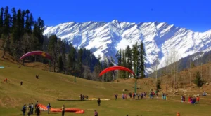
The Vaishno Devi elevation shapes almost every part of the pilgrimage experience — from the weather you pack for to pacing on the trek and the views encountered along the way. At roughly 1,585 m above sea level, temperatures are cooler than the plains; mornings and evenings can be brisk throughout much of the year, and winter months bring a starker chill (and occasional snow in higher nearby ridges). This makes clothing choices, hydration and footwear key parts of planning. :contentReference[oaicite:2]{index=2}
Elevation & climate — a practical comparison
| Feature | At Vaishno Devi (~1,585 m) | Plains / Sea-level |
|---|---|---|
| Summer (Apr–Jun) | Pleasant to mild; cooler mornings | Hot and humid |
| Monsoon (Jul–Sep) | Frequent showers; slippery sections | Heavy rain, higher heat index |
| Winter (Dec–Feb) | Cold; possible snowfall in surrounding high ridges | Cool to mild; snowfall rare |
Planning the spiritual trek — altitude-aware tips
The physical climb and the high-altitude setting make preparation especially important for comfortable darshan and safe trekking. Here are tested tips for pilgrims planning the Vaishno Devi yatra:
- Pace yourself: The trail is uphill overall — take regular rests, especially if you feel breathless climbing stairs or steep sections.
- Layered clothing: Pack a light thermal or fleece even in summer — temperatures fall quickly after sunset and at higher vantage points.
- Hydration & snacks: Carry water and light snacks; energy shops and stalls exist along the route but price/availability varies on peak days.
- Monsoon caution: If you travel during the rains, choose footwear with good grip; some sections get slippery.
- Accessibility: Battery vehicles, ponies and palkis are available; reserve in advance during festivals and peak seasons. :contentReference[oaicite:3]{index=3}
Transport options & altitude shortcuts
Most pilgrims start at Katra (base town). From Katra you can walk the main route (the traditional yatra), use ponies/palkis, hire battery-operated vehicles for part of the path or take helicopter services (helicopter landings operate seasonally and subject to Shrine Board schedules and weather). Helicopter transfers effectively shortcut the trek for those prioritizing time or with mobility constraints. Always check official Shrine Board updates for current helicopter and vehicle arrangements before travel. :contentReference[oaicite:4]{index=4}
Elevation milestones on the route (cheat-sheet)
| Milestone | Approx. distance from Katra | Altitude (approx.) |
|---|---|---|
| Banganga | ~1 km | ~850–900 m (relative to Katra baseline) |
| Charan Paduka | ~2.5 km | ~1,030 m (local variations) |
| Adhkuwari (Aadhi-khwari) | ~6 km | Higher ridge; variable |
| Bhawan (main shrine) | ~12 km | ~1,585 m / 5,200 ft |
Health & safety at altitude
At ~1,585 m most healthy visitors experience no acute altitude illness. Still, those with cardiac or respiratory conditions should consult a physician before attempting the trek. If you feel lightheaded, excessively breathless, or dizzy, rest and seek help from medical points along the route or use assistance services. The Shrine Board maintains medical facilities and rescue services around the yatra path. :contentReference[oaicite:5]{index=5}
Conclusion — altitude enriches the pilgrimage
The Vaishno Devi height from sea level (≈1,585 m) is not just a geographic fact — it frames the pilgrimage’s sensory experience: cool mountain air, uphill devotion, and horizons that open as you climb. Whether you’re walking the traditional path from Katra, using a pony, or taking a helicopter for time-saving convenience, understanding the altitude helps you pack smarter, pace better, and cherish the spiritual journey more fully.
Target keywords: vaishno devi height from sea level, vaishno devi elevation, vaishno devi altitude, vaishno devi above sea level
Sources
- Wikipedia — Vaishno Devi Temple (elevation listed ~1,585 m).
- Shri Mata Vaishno Devi Shrine Board — distances & altitudes along the route.
- Incredible India — destination summary and elevation reference.
- AllTrails — trek distance and elevation gain (user route data).
- Helicopter transfer & travel notes.
Height of Dalhousie from Sea Level Dharamshala Height from Sea Level


 10")