Mussoorie Height from Sea Level

Mussoorie Height from Sea Level – The Queen of Hills
Everything you need to know about Mussoorie height from sea level, how Mussoorie elevation shapes weather, and why its altitude keeps travelers coming back.
Mussoorie Elevation — Quick Facts
| Mussoorie altitude (town average) | ≈ 2,000–2,005 m (≈ 6,560–6,580 ft) |
| Highest point near town (Lal Tibba, Landour) | ≈ 2,275–2,290 m (≈ 7,465–7,515 ft) |
| Other key spots | Gun Hill ≈ 2,020 m; Kempty Falls ≈ 1,364 m; Dhanaulti ≈ 2,286 m |
| Nickname | The Queen of Hills |
Why Mussoorie’s Height from Sea Level Matters
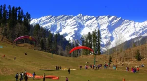
Perched roughly two kilometers above sea level, Mussoorie Height from Sea Level sits along a horseshoe-like ridge with the Doon Valley on one side and the Garhwal Himalaya on the other. This ridge-top setting naturally moderates temperatures, keeps the air crisp, and serves up horizon-spanning views—big reasons why the Mussoorie elevation has drawn travelers, writers, and honeymooners for more than a century.
Elevation & Weather — What You’ll Feel
- Pleasant Summers (Apr–Jun): Daytime is comfortable; evenings invite strolls on The Mall and the Ridge.
- Monsoon Magic (Jul–Sep): Mist swirls through deodar forests; vistas appear and vanish—carry a light shell and grippy footwear.
- Clear Autumns (Oct–Nov): Long-range views open up; sunrise and sunset photography shines.
- Chilly Winters (Dec–Feb): Cold nights; occasional snowfall on nearby higher points like Landour and Lal Tibba.
Mussoorie vs Sea Level — Simple Comparison
| Feature | Mussoorie (≈2,000 m) | Sea-Level City |
|---|---|---|
| Summer Feel | Mild days, cool evenings | Hot to very hot; often humid |
| Winter Conditions | Cold; higher areas may see snow | Cool to mild; snow rare |
| Air & Visibility | Crisp mountain air; sweeping mountain/valley vistas | More pollution/haze; shorter horizons |
The Queen of Hills: What Mussoorie’s Altitude Adds to Your Trip
The beauty of Mussoorie above sea level is how varied the experiences are within short distances. At town level, cafés and promenades offer relaxed sightseeing. A few kilometers uphill, Landour turns the thermostat down another notch with pine-scented lanes and heritage bungalows. Climb further to Lal Tibba, the region’s highest viewpoint, and you get wide Himalayan panoramas; drop down towards Kempty Falls and the air warms, great for family picnics and a splash. This micro-variation in climate and scenery is pure altitude magic.
Best by Interest (Seasonal Pointers)
| Interest | Best Window | Why Elevation Helps |
|---|---|---|
| Cool Summer Escape | April–June | Town temps stay pleasant vs. plains heat |
| Mist & Greens | July–September | Monsoon revives forests; dramatic cloud play |
| Long-View Photography | October–November | Dry air; crystal horizons from ridge lookouts |
| Light Snow Chasing | December–February (variable) | Higher spots like Lal Tibba & Landour get colder |
Mussoorie & Around — Elevation Cheat Sheet
| Place | Approx. Altitude | What it Means for Visitors |
|---|---|---|
| Mussoorie (town core) | ~2,000–2,005 m (~6,560–6,580 ft) | Pleasant in summer; chilly winter evenings |
| Landour (cantonment) | ~2,200–2,300 m | Quieter lanes; cooler than town center |
| Lal Tibba (highest viewpoint) | ~2,275–2,290 m | Wide Himalayan panoramas on clear days |
| Gun Hill | ~2,020 m | Quick viewpoint via ropeway/walk; 360° vistas |
| Kempty Falls | ~1,364 m | Warmer than ridge; family-friendly splash spot |
| Dhanaulti | ~2,286 m | Cooler, quieter day trip; eco parks & forest walks |
Comfort & Health at ~2,000 m
At Mussoorie Height from Sea Level , most healthy travelers feel fine. You may breathe a little harder on steep lanes, but serious altitude issues are rare compared with very high Himalayan towns. Keep day one light, sip water regularly, and pack layers—temperatures swing faster at elevation, especially after sunset and during winter.
Smart Packing for an “Above Sea Level” Getaway
- Layers: Base tee, light fleece, wind/water shell; add a warm jacket for winter nights.
- Footwear: Good grip for slopes and wet monsoon pavements.
- Sun Care: UV is stronger at altitude—sunglasses and SPF help.
- Hydration & snacks: Useful for viewpoint walks and day trips.
Suggested One-Day Altitude Trail
- Morning: Easy town-level walk (The Mall, Camel’s Back Road) to acclimatize.
- Late Morning: Head up to Landour & Lal Tibba for cooler air and Himalayan views.
- Afternoon: Return to town cafés for a relaxed lunch; if skies are clear, take the ropeway or walk to Gun Hill.
- Evening: If you fancy warmer air, drive down towards Kempty Falls (earlier in winter months for daylight) or enjoy sunset back on the ridge.
FAQs — Mussoorie Height, Weather & Travel
Q. What is Mussoorie’s exact height from sea level?
The town sits at roughly 2,000–2,005 metres above sea level, depending on the point along the ridge.
Q. What’s the highest point around Mussoorie?
Lal Tibba near Landour is the highest commonly visited viewpoint, around 2,275–2,290 m.
Q. Is Mussoorie good in summer?
Yes—its elevation keeps summers much cooler than the plains. Evenings can be breezy, so carry a light layer.
Q. Where can I find snow?
Snow is never guaranteed, but higher spots like Landour and Lal Tibba are your best bet in colder spells (Dec–Feb).
Key Takeaway
The Mussoorie height from sea level is more than a number—it’s why the town feels fresh, scenic, and endlessly walkable. From café-lined promenades to high lookouts, the Mussoorie elevation delivers cooler weather, cleaner air, and layered landscapes within a few kilometers. If you’re planning a family trip, a romantic escape, or a photography run, Mussoorie’s altitude guarantees variety and views in every season.
Planning by altitude and season? Check live updates and travel tips for Himachal & Uttarakhand on
ManaliWeather.com.
Target Keywords: mussoorie height from sea level, mussoorie elevation, mussoorie altitude, mussoorie above sea level
Sources & Further Reading
- Uttarakhand Tourism — Mussoorie overview (~2,000 m)
- Wikipedia — Mussoorie elevation (~2,005 m)
- Encyclopaedia Britannica — Mussoorie elevation (~2,112 m)
- MakeMyTrip — Lal Tibba (~2,290 m)
- Travel Chardham — Lal Tibba (~2,275 m)
- eUttaranchal — Gun Hill viewpoint
- Wikipedia — Kempty Falls altitude (~1,364 m)
- Wikipedia — Dhanaulti elevation (~2,286 m)
Manali Altitude in Meters
Manali Height from Sea Level


 10")
1 thought on “Mussoorie Height from Sea Level”