Badrinath Height from Sea Level

Badrinath Height from Sea Level — Badrinath Elevation & Sacred Pilgrimage in the Himalayas
Everything about badrinath height from sea level, how badrinath elevation shapes climate, pilgrimage access and what travellers should know about altitude and weather.
Badrinath Height from Sea Level — quick answer
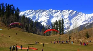
Badrinath — one of the four Char Dham pilgrimage sites — is perched high in the Garhwal Himalaya at roughly 3,133 metres (≈10,279 feet) above sea level. This altitude places the temple town well into the high hill zone, where mountain weather, short summers and a limited pilgrimage season are the norm. :contentReference[oaicite:0]{index=0}
Quick facts table
| Item | Details |
|---|---|
| Badrinath height from sea level (temple/town) | ≈ 3,133 m (10,279 ft). Sources sometimes round to ≈3,100 m depending on measurement point. :contentReference[oaicite:1]{index=1} |
| District & river | Chamoli district, Uttarakhand; on the banks of the Alaknanda River. :contentReference[oaicite:2]{index=2} |
| Pilgrimage season | Temple typically open April/May to October/November — closed in harsh winter due to snow and access issues. :contentReference[oaicite:3]{index=3} |
Why altitude matters: climate, access and pilgrimage
The badrinath elevation directly determines local climate and access. At over three thousand metres, Badrinath experiences a short, cool summer window suitable for the pilgrimage. Heavy snowfall, road closures and sub-zero temperatures in winter make the shrine inaccessible for months — which is why the temple follows a seasonal opening schedule. High altitude also means thinner air, clearer skies (on good days) and sharply cooler nights compared with lowland towns. :contentReference[oaicite:4]{index=4}
Elevation & seasonal impact (table)
| Season | Typical conditions at ≈3,133 m | Pilgrimage notes |
|---|---|---|
| Spring (Apr–Jun) | Cold mornings; gradually warming days; melting snow in approach routes. | Main opening window — roads cleared; darshan resumes. :contentReference[oaicite:5]{index=5} |
| Monsoon (Jul–Sep) | Frequent rains at lower elevations, but Badrinath often remains cool with cloud cover and occasional landslip risks on approaches. | Pilgrimage continues but travelers should monitor road/weather alerts. :contentReference[oaicite:6]{index=6} |
| Autumn (Oct–Nov) | Clear skies, cold nights; good visibility for Himalayan views. | Last reliable window before winter closure. :contentReference[oaicite:7]{index=7} |
| Winter (Dec–Mar) | Heavy snowfall, roadblocks, sub-zero temperatures; most services suspended. | Temple closed; only locals or organized expeditions remain. :contentReference[oaicite:8]{index=8} |
What elevation means for pilgrims & visitors
Travellers often ask whether they need to worry about altitude sickness at Badrinath. At ~3,100 m some visitors—especially those coming quickly from sea-level cities—may notice shortness of breath, disturbed sleep or mild headache. These effects are usually mild and manageable with pace control, hydration and a relaxed itinerary. For those planning strenuous excursions (treks, high passes nearby), allow time to acclimatise and consult local guides. :contentReference[oaicite:9]{index=9}
Packing & planning checklist
- Layered clothing — warm jacket, fleece, and windproof shell.
- Comfortable walking shoes with good grip (approach routes can be rocky).
- Sensible pacing on arrival — avoid heavy exertion first day.
- Sun protection — UV is stronger at altitude (sunglasses, sunscreen).
- Check road & weather advisories for the Char Dham routes before travel. :contentReference[oaicite:10]{index=10}
Badrinath & the Char Dham — altitude in context
Badrinath’s elevation is notable even among pilgrimage sites: its high altitude contributes to its remote, sacred character and limited seasonal accessibility. Pilgrims typically combine Badrinath with nearby high-altitude destinations (like Joshimath and Hemkund) when planning a Char Dham or Uttarakhand pilgrimage circuit. Improvements in roads and services have made access easier in recent years — but they also increase environmental pressure on fragile Himalayan terrain, so travellers should choose sustainable options and follow local guidance. :contentReference[oaicite:11]{index=11}
Nearby altitude reference table
| Place | Approx. Altitude | Notes |
|---|---|---|
| Badrinath (town / temple) | ~3,133 m (10,279 ft) | Pilgrimage hub on Alaknanda’s banks. :contentReference[oaicite:12]{index=12} |
| Joshimath (approach town) | ~1,890 m (6,200 ft) | Common staging point for Badrinath access; subject to local geohazards. :contentReference[oaicite:13]{index=13} |
| Hemkund Sahib (nearby pilgrimage lake) | ~4,329 m (14,200 ft) | Much higher — requires acclimatisation and trekking. (Reference: regional pilgrimage sources) |
Conclusion — altitude is part of the experience
The badrinath height from sea level (~3,133 m) shapes everything about the pilgrimage: the brief, treasured visiting season, the crisp mountain air, the dramatic Himalayan backdrop and the need for sensible planning by visitors. Treat altitude respectfully — plan for gradual arrival, pack layers, and keep flexible travel plans in case of weather or road changes. The reward is a spiritually resonant place set in one of the most striking high-altitude landscapes of India.
Target keywords: badrinath height from sea level, badrinath elevation, badrinath altitude, badrinath above sea level
Sources
- Wikipedia — Badrinath town & temple (elevation references).
- Char Dham overview and Badrinath elevation context.
- CharDhamYatra.net — Badrinath Dham elevation & pilgrimage notes.
- Regional pilgrimage guides — altitude & travel tips.
- News coverage about regional access and geohazards around Char Dham routes.
Gangtok Height from Sea Level Mount Everest Height from Sea Level


 10")