Dharamshala Height from Sea Level

Dharamshala Height from Sea Level & Dharamshala Elevation — Spiritual Hill Station in Himachal
Discover the Dharamshala height from sea level, how Dharamshala elevation shapes its weather and culture, and why its altitude makes it a serene spiritual and trekking hub.
At a glance — Dharamshala elevation
Dharamshala sits in the Kangra Valley at varying heights: Lower Dharamshala lies roughly around 1,380–1,475 metres (≈4,528–4,839 ft), while Upper Dharamshala — including McLeod Ganj and the Dalai Lama’s residence — averages closer to 1,770–1,830 metres (≈5,807–6,004 ft). This town-on-a-ridge character means that when people search for dharamshala height from sea level or dharamshala altitude, the precise number depends on which neighbourhood you mean. :contentReference[oaicite:0]{index=0}
Quick facts table
| Place / Metric | Approx. Elevation | Notes |
|---|---|---|
| Lower Dharamshala (town core) | ~1,380–1,475 m (4,528–4,839 ft) | Commercial centre, milder than upper reaches. :contentReference[oaicite:1]{index=1} |
| Upper Dharamshala / McLeod Ganj | ~1,770–2,082 m (5,800–6,831 ft) | Spiritual centre, Tibetan community, cooler and greener. :contentReference[oaicite:2]{index=2} |
| Naddi / Triund base (nearby) | ~2,000 m (Triund trek start) | Popular short treks and viewpoint access. :contentReference[oaicite:3]{index=3} |
How elevation shapes Dharamshala’s weather and seasons
Elevation affects temperature, rainfall and even the feel of each season. At town level (1,300–1,500 m) summers are mild and pleasant compared with the Indian plains; monsoon months bring heavy, misty rain to the valley and forests; and winters are cool with occasional snowfall possible in higher pockets such as McLeod Ganj and nearby ridges. The local microclimate varies quickly as you move up or down the slopes, so packing in layers is essential. :contentReference[oaicite:4]{index=4}
Elevation vs. average feel — quick comparison
| Feature | Lower Dharamshala (~1,400 m) | McLeod Ganj (~1,800–2,000 m) |
|---|---|---|
| Summer Temperatures | Pleasant (day warm, nights cool) | Cooler days; crisp evenings |
| Monsoon | Heavy rains; lush valley | Intense mist; reduced visibility |
| Winter | Chilly, frost possible in cold spells | Colder; chance of snowfall around high ridges |
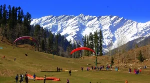
Why Dharamshala altitude draws travelers — spiritual, trekking & nature mix
Dharamshala’s altitude creates a peaceful mountain ambience that suits spiritual retreats, short treks (Triund, Indrahar Pass approaches), meditation stays and cultural visits to the Tibetan community in McLeod Ganj. The cooler climate makes it an appealing summer escape from the plains; the Dhauladhar skyline frames sunrise and sunset views that photographers and trekkers prize. :contentReference[oaicite:5]{index=5}
Practical travel tips for altitude-aware visitors
- Allow gentle activity on arrival — the difference between lower and upper Dharamshala can be noticeable after long road travel. :contentReference[oaicite:6]{index=6}
- Pack layers: t-shirts + fleece + windproof shell; nights cool even in summer.
- Carry rain protection in monsoon months (July–September) as heavy showers are common. :contentReference[oaicite:7]{index=7}
- If you plan treks (Triund, Indrahar), check local trail conditions — altitude gain matters more than the town’s base height.
Dharamshala altitude snapshots — places to know
| Place | Approx. Altitude | Why visit |
|---|---|---|
| Lower Dharamshala | ~1,380–1,475 m | Markets, local life, access to valley roads. :contentReference[oaicite:8]{index=8} |
| McLeod Ganj | ~1,770–2,082 m | Tibetan culture, Dalai Lama temple, cooler climes. :contentReference[oaicite:9]{index=9} |
| Triund (trek) | ~2,850 m (summit ~2,850 m depending on route) | Alpine views, panoramic Dhauladhar skyline (trail difficulty varies). |
Conclusion — altitude, atmosphere & authenticity
The dharamshala height from sea level is not a single number but a range — a ribbon of elevations from valley floor to ridge-top that creates the town’s layered character. Whether you seek peaceful spiritual retreats in McLeod Ganj, scenic treks from Naddi and Triund, or simply a cool respite from the plains, Dharamshala’s elevation is a defining asset. Plan according to the neighbourhood you’ll stay in, pack in layers, and enjoy the vivid mountain moods that altitude brings. :contentReference[oaicite:10]{index=10}
Sources & further reading
- Wikipedia — Dharamshala & McLeod Ganj (elevation ranges and town split). :contentReference[oaicite:11]{index=11}
- Weatherspark — Dharamshala topography and climate summaries. :contentReference[oaicite:12]{index=12}
- Incredible India — McLeod Ganj altitude & tourism notes. :contentReference[oaicite:13]{index=13}
- Britannica — regional geography & background on Kangra valley. :contentReference[oaicite:14]{index=14}
- The Guardian — reporting on tourism pressure in McLeod Ganj (context on visitor patterns). :contentReference[oaicite:15]{index=15}


 10")
2 thoughts on “Dharamshala Height from Sea Level”